


Underwater Drones Reveal Hidden Coral Habitat: Why Marine Baseline Surveys Need to Look Deeper
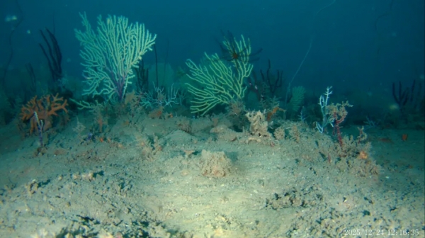
For more than half a century, coral structures reported off the coast of Benin remained largely unresolved.
Marine surveys conducted in the 1960s had identified what appeared to be a deep reef barrier more than 50 metres below the surface.
But because those surveys were designed primarily to assess fishing grounds rather than investigate coral ecology, the habitat was never adequately characterised.
Its living status remained uncertain.
In 2025, researchers returned with a very different set of tools.
They combined historical records, side-scan sonar, an underwater drone and a stationary deep-sea camera system.
What they found was not simply an old geological structure.
At approximately 54 metres depth, they documented living coral communities, reef-associated fish and complex hard-bottom habitat on the Benin continental shelf.
The discovery provides an important lesson for marine environmental management:
What we fail to detect can depend as much on how we survey as on what is actually present.
What exactly did the researchers find?
The peer-reviewed study was led by Coffi Gérard Franck Zinzindohoué of the Institut de Recherches Halieutiques et Océanologiques du Bénin and published in Frontiers in Marine Science.
The researchers report living mesophotic coral communities on rocky substrate at approximately 54 metres depth.
The assemblage contained at least:
- Six visually distinct octocoral morphotypes
- Two black-coral taxa
- Eight reef-associated fish species
The coral communities were dominated by octocorals, including gorgonian sea fans.
Framework-building scleractinian corals—the hard corals that create many familiar shallow tropical reefs—were comparatively scarce.
For that reason, the researchers describe the ecosystem more specifically as a mesophotic coral garden.
That terminology is important.
The discovery is ecologically significant, but the habitat should not be represented as a conventional shallow-water hard-coral reef simply because the word “reef” is more familiar.
What is a mesophotic coral ecosystem?
Mesophotic coral ecosystems occur below the depths normally associated with shallow tropical reefs but still within waters where enough light penetrates to support light-dependent organisms.
Depending on water clarity and local conditions, such ecosystems can extend to depths approaching approximately 150 metres.
They can contain corals, sponges, fishes and other organisms adapted to conditions of reduced light.
They may also differ substantially from shallower reefs in community composition and environmental conditions.
The Benin habitat was found at approximately 54 metres—well below ordinary recreational diving depths and therefore much less accessible to conventional visual survey methods.
This accessibility problem helps explain why mesophotic habitats remain comparatively poorly documented in many regions.
The discovery began with information nearly 60 years old
The researchers did not search the continental shelf randomly.
They began with historical surveys conducted in 1963 and 1964.
Those earlier investigations were undertaken primarily to map fishing grounds along the coasts of what are now Benin and Togo.
The historical reports identified potential coral structures, but their ecological status was unresolved.
Rather than discard those old observations, the modern team used them as a starting point.
That decision illustrates the continuing value of historical environmental records.
Old bathymetric maps, ecological reports, sediment surveys, fisheries observations and baseline datasets may contain information that can be revisited using technologies unavailable when the original surveys were conducted.
Step one: map the seabed acoustically
Between April and May 2025, the researchers conducted 35 side-scan sonar transects.
Individual transects ranged from only a few metres to more than a kilometre, producing a cumulative survey distance of approximately 11.5 kilometres.
Side-scan sonar does not photograph the seabed in the conventional sense.
It sends acoustic signals toward the seafloor and records the returning energy.
Different seabed materials and structures generate different acoustic responses.
Researchers can therefore identify features that may represent rocky substrate, relief, debris, sediment changes or other structures requiring closer investigation.
In Benin, sonar revealed two spatially distinct areas of elevated acoustic backscatter within an otherwise predominantly sandy environment.
These acoustic targets became priorities for direct visual investigation.
Step two: ground-truth the sonar
A sonar signal alone cannot demonstrate that coral is alive.
It cannot even establish with certainty that a particular hard acoustic return is coral habitat.
That requires ground-truthing.
The researchers therefore deployed a tethered underwater drone fitted with a 4K camera and high-output lights.
They also used the National Geographic Deep Sea Camera System—a stationary video platform capable of operating at depth.
The underwater imagery confirmed that at least some of the hard-bottom structures identified acoustically supported living coral communities.
This sequence illustrates a powerful marine-survey strategy:
Broad-area detection → target identification → direct verification.
Each method answers a different question.
Sonar identifies where unusual seabed structures may exist.
Underwater imagery shows what those structures actually support.
Physical sampling, if permitted and appropriate, can then confirm species identification, geological composition and other properties that imagery alone cannot resolve.
The researchers did not survey the whole supposed reef barrier
This is one of the most important limitations.
Historical reports suggested a potentially much larger coral structure extending along the continental shelf.
The modern research did not map all of it.
The team’s acoustic observations covered a west-east extent of approximately 7 kilometres, and visual investigation was limited further.
Because of budgetary and logistical constraints, underwater-drone surveys were conducted only at the first identified reef complex.
The researchers explicitly describe the project as exploratory.
It was designed to detect and confirm living coral habitat—not calculate complete coral coverage or produce an exhaustive habitat map for the Benin continental shelf.
That distinction should prevent a tempting but unsupported conclusion:
The study did not discover a continuously living 40-kilometre reef.
It confirmed living coral communities at discrete locations within the area investigated.
Coral identification remains provisional
No physical coral specimens were collected.
The research team therefore identified corals from high-resolution imagery using characteristics such as colony form, branching pattern, skeletal appearance and polyp arrangement.
At least six octocoral morphotypes and two black-coral taxa could be distinguished visually.
But species-level identification was considered preliminary because skeletal examination and genetic analysis were not performed.
This is another example of why different survey methods complement rather than replace one another.
Underwater video is exceptionally useful for confirming habitat presence without destructive sampling.
But some taxonomic questions still require physical specimens or genetic techniques.
Eight fish species were observed—but the camera method matters
Researchers also recorded eight fish species associated with the coral habitat.
These included fishes observed sheltering or feeding among the coral structures.
However, some observations came from a baited stationary camera system.
Bait is useful because it increases the probability of recording mobile animals.
But it can also influence which animals approach the camera.
The researchers explicitly acknowledge that fish observations may therefore have been biased toward scavenging or predatory species attracted to the bait.
The eight documented species should consequently be interpreted as species observed during the exploratory survey, not as a complete inventory of the local fish community.
What were environmental conditions at 54 metres?
The deep-camera system also carried environmental sensors.
During five deployments close to the seabed at approximately 50–60 metres depth, researchers recorded bottom-water temperatures ranging from 18.9°C to 25.9°C.
Dissolved-oxygen saturation ranged from 44.5% to 92.5%.
Measured dissolved-oxygen concentrations ranged from 104.4 to 197.7 µmol/L.
The coral communities occurred within a thermocline—a depth interval in which temperature changes rapidly.
Historical observations from the region also indicate substantial seasonal variability in subsurface water temperature.
But the modern measurements were collected during a limited number of deployments.
The authors therefore caution that they cannot determine seasonal variability or long-term environmental change from these measurements alone.
A few environmental measurements can establish conditions during a survey.
They do not automatically establish the long-term environmental envelope of an ecosystem.
Was the reef dead and then revived?
The popular description of the site as a coral reef “presumed dead” makes a compelling headline.
Scientifically, the history is less certain.
The 1960s surveys identified reef-like structures but were not designed to provide the ecological evidence necessary to document coral condition in the way a modern benthic survey would.
The new study therefore cannot determine whether:
- Living coral was present in the 1960s but overlooked
- Coral condition subsequently changed
- Previously damaged coral habitat recovered
- The historical reports referred to exactly the same coral patches now observed
The researchers themselves state that more information is needed to reconstruct the history of the habitat.
A more defensible description is therefore:
A coral habitat whose living status had remained unresolved for decades was confirmed using modern marine-survey technology.
Why the substrate matters
The corals were not growing across featureless sand.
They occurred on consolidated rocky substrate.
This matters because suitable hard substrate often determines where many attached benthic organisms can establish.
The side-scan sonar detected hard-bottom features standing above the surrounding seabed.
In one area, mapped structures reached up to 7.4 metres in relief; in another, a structure reached approximately 10.3 metres.
Those structures create physical habitat.
They provide surfaces for attached organisms and three-dimensional complexity for other species.
That means marine habitat assessment may require more than water sampling.
Understanding the seabed itself can be essential.
Why baseline surveys can miss important habitats
Marine baseline studies are usually constrained by practical realities.
Survey vessels cost money.
Dive time is limited.
Weather creates narrow operational windows.
Deep sites may require specialist equipment.
Large marine areas cannot be inspected visually point by point.
Sampling programmes therefore rely on representative locations.
That makes survey design critical.
If the locations selected do not include deeper hard-bottom habitat, the resulting baseline may accurately describe the sampled stations while still missing ecologically important areas elsewhere.
The Benin study demonstrates how a tiered approach can reduce that risk.
Historical information and acoustic mapping can first identify environmental heterogeneity.
More expensive visual or physical investigations can then be concentrated on the areas most likely to contain distinctive habitat.
“No habitat detected” is not always the same as “no habitat exists”
This distinction has broad environmental significance.
When a survey fails to detect a species or habitat, several explanations are possible.
It may genuinely be absent.
But it may also have been:
- Outside the survey area
- Deeper than the sampling programme reached
- Present at low density
- Seasonal
- Difficult to identify with the method used
- Located on seabed types that were undersampled
- Missed because visibility was poor
- Beyond the resolution of the survey technology
Environmental professionals therefore need to interpret absence of detection cautiously.
This is particularly important during baseline studies used to support marine development, dredging, offshore infrastructure or spatial planning.
Why this matters for Trinidad and Tobago
Trinidad and Tobago has extensive marine environments with very different oceanographic and ecological characteristics from Benin.
The Benin finding should not be interpreted as evidence that similar undiscovered coral gardens exist around Trinidad or Tobago.
Local investigation would be required.
But the survey-design lesson is directly relevant.
The Institute of Marine Affairs has maintained long-term reef-monitoring locations around Tobago and publishes spatial information on its coral transects.
Its documented monitoring sites include reef areas ranging from shallow depths to approximately 40 metres at Blackjack Hole, while several other sites extend to around 20–30 metres.
That work provides valuable long-term information on Tobago’s known reefs.
For example, IMA’s 2010–2019 assessment analysed changes in benthic composition across ten reef sites and documented long-term changes following the 2010 bleaching event.
The Benin study does not undermine such monitoring.
Instead, it highlights a complementary question:
Are established monitoring locations representative of every habitat that may be relevant to a particular project or development footprint?
Long-term monitoring and exploratory baseline mapping serve different purposes.
Both can be necessary.
Existing reef monitoring shows why continuity matters
The IMA’s Tobago coral programme demonstrates the value of repeatedly monitoring the same locations.
Repeated transects allow researchers to identify trends that a single survey would not reveal.
The Benin study demonstrates the opposite but complementary value of exploration.
Where monitoring asks:
How is a known ecosystem changing?
Exploratory mapping asks:
What ecosystems are present in the first place?
A strong marine environmental programme may need both.
Relevance to offshore development and marine spatial planning
This becomes particularly important where human activity expands across the continental shelf.
Potential pressures can include:
- Offshore infrastructure
- Pipelines and cables
- Anchoring
- Dredging
- Bottom-contact fishing
- Port development
- Sediment disturbance
- Waste or effluent discharges
The Benin authors specifically identify bottom-contact fishing and other increasing pressures on continental-shelf environments as reasons mesophotic habitats should be incorporated into regional assessments and marine spatial planning.
A habitat does not need to be visible from the surface to be environmentally important.
A practical marine baseline framework
For projects where poorly characterised seabed habitat may occur, a defensible investigation could use several stages.
1. Review existing evidence
Before field deployment, compile:
- Historical surveys
- Bathymetric information
- Navigation charts
- Previous ecological reports
- Sediment data
- Fisheries information
- Existing GIS layers
- Satellite and remote-sensing information where relevant
Old information should not automatically be treated as obsolete.
It can help determine where new investigation is needed.
2. Map environmental heterogeneity
Where appropriate, acoustic tools can identify differences in seabed character over areas too large for direct visual inspection.
Potential hard bottom, sediment transitions and seabed structures can then be mapped.
The output is not yet an ecological conclusion.
It is a set of targets.
3. Ground-truth the targets
Selected areas should then be investigated directly using the most appropriate method.
Depending on depth and objectives, this might include:
- Divers
- Underwater cameras
- Remotely operated vehicles
- Drop cameras
- Grab samples
- Sediment cores
- Other specialist tools
4. Measure environmental conditions
Habitat observations become more informative when paired with environmental data.
Potential variables include:
- Depth
- Temperature
- Dissolved oxygen
- Salinity
- Turbidity
- Currents
- Sediment characteristics
- Water chemistry
5. Establish repeatable monitoring locations
Once important habitat is identified, permanent or repeatable stations can allow future change to be assessed.
That transforms exploration into long-term environmental intelligence.
Technology does not remove the need for good survey design
Underwater drones are becoming increasingly capable.
But technology alone does not make a survey scientifically defensible.
The Benin team still needed historical information to choose the study area.
Sonar interpretation was required to identify targets.
Visual observations were needed to verify habitat.
Environmental sensors provided context.
Expert taxonomists assisted with image-based coral and fish identification.
And the authors still acknowledge important uncertainties.
The value therefore lies not in one instrument but in integrating methods so that each compensates for limitations in another.
The danger of overstating “AI” or autonomous monitoring
Marine robotics, automated image analysis and artificial intelligence are increasingly entering ecological monitoring.
They can be extremely valuable.
But an image-classification system can only interpret what the camera sees.
A camera can only observe where it is deployed.
And a drone can only survey the route it is instructed to follow.
Technology increases coverage and analytical capacity.
It does not eliminate sampling bias.
That distinction will become increasingly important as environmental monitoring becomes more automated.
Where Ecotox can contribute
Ecotox Environmental Services lists several verified capabilities relevant to marine baseline investigations.
These include:
- Marine water and sediment surveys
- Environmental baseline surveys
- Marine ecological surveys
- Environmental sampling-programme design
- Marine water sampling
- Sediment sampling
- Monitoring of offshore installations
- Environmental monitoring-programme implementation
These capabilities can support the environmental characterisation component of marine investigations.
However, Ecotox’s current verified public service information does not establish that it operates side-scan sonar, ROV systems or underwater drones.
Those capabilities should therefore not be implied.
Where a project requires hydrographic mapping, specialist geophysics, deep-water imaging or robotic surveys, Ecotox can appropriately contribute through environmental survey design, water and sediment assessment, ecological investigation and multidisciplinary coordination with specialist partners where required.
That is a stronger and more defensible position than claiming every technical capability in-house.
The deeper lesson for environmental assessment
The most important result from Benin may not be any particular coral species.
It is what the discovery says about environmental knowledge.
For decades, the habitat remained effectively outside modern ecological assessment.
It was not necessarily absent.
It was poorly observed.
That difference matters.
Environmental baselines are always shaped by the methods, locations, depths and frequency of observation.
A baseline therefore should not simply answer:
What did we find?
It should also ask:
Where did we look, how did we look, and what could our method have missed?
Conclusion
Researchers off Benin used historical survey records, side-scan sonar and underwater imaging to confirm a living mesophotic coral ecosystem at approximately 54 metres depth.
The habitat was dominated by octocorals and included black corals and reef-associated fishes.
It is, according to the researchers, the first confirmed living mesophotic coral ecosystem documented on the Benin continental shelf and the first known from the Gulf of Guinea continental shelf.
But this was an exploratory discovery.
The researchers did not map the full historical reef barrier.
They did not quantify coral cover across the shelf.
Coral identifications remain provisional without specimens or genetic confirmation.
And their environmental measurements are insufficient to establish long-term trends.
Those limitations make the study more useful—not less.
They show how environmental knowledge develops in stages:
Historical evidence → acoustic detection → visual confirmation → sampling → quantitative mapping → long-term monitoring.
For Trinidad and Tobago, the finding does not prove that undocumented mesophotic coral systems exist locally.
It demonstrates something more broadly applicable:
Marine environmental baselines are only as complete as the areas, depths and methods used to build them.
Sometimes, improving environmental intelligence means simply looking deeper.
Linked Sources
Frontiers — Underwater drones discover coral reefs off Benin, long presumed dead, teeming with life
Institute of Marine Affairs — Tobago Coral Reef Transects and Monitoring Data
Institute of Marine Affairs — Benthic Composition of Tobago Coral Reefs, 2019 and 2010–2019 Summary
Ecotox Environmental Services — Consultancy & Speciality Projects
Ecotox Environmental Services — Specialized Sampling Services