


Wildfire Emissions Below the Surface: Why Soil, Peat and Air Monitoring Must Work Together
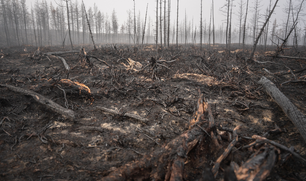
When a wildfire moves through a forest, attention naturally focuses on flames, smoke and burned vegetation. Yet some of the most consequential combustion may occur out of sight—in leaf litter, organic soil horizons and peat beneath the surface.
A new study of Canada’s record-breaking 2023 wildfire season estimates that soil and peat combustion accounted for approximately three-quarters of the carbon released by the fires. The finding strengthens the case for wildfire assessments that look beyond burned trees and visible smoke.
It also highlights an important distinction: estimating the amount of carbon consumed by a fire is not the same as measuring community exposure to particulate matter or determining the chemical composition of the smoke. Carbon accounting, air-quality monitoring and post-fire environmental testing answer different—but complementary—questions.
What the Canadian study found
The research, published in Geophysical Research Letters, examined the unprecedented 2023 Canadian wildfire season. The researchers estimated that:
- Approximately 15.1 million hectares burned—about seven times the recent 20-year average.
- The fires released an estimated 554 ± 51 teragrams of carbon, equivalent to 554 million tonnes of carbon.
- Approximately 423 ± 27 million tonnes, or 76%, came from soil organic matter and peat.
- Live above-ground vegetation accounted for the remaining 24%.
- Peatlands represented approximately 34% of the burned area and contributed an estimated 180 ± 15 million tonnes of carbon—close to one-third of the total.
- Canada’s fires accounted for an estimated 23% of global wildfire carbon emissions during that year.
These figures are estimates developed by integrating field observations, satellite-derived burned-area information, fire-weather data and datasets describing above-ground biomass and soil organic carbon.
They are not direct measurements of every fire or plume. Burn depth, fuel moisture, carbon density and combustion completeness vary across landscapes, creating uncertainty that must be considered when interpreting national-scale totals.
Carbon is not the same measurement as carbon dioxide
The paper reports emissions as a mass of carbon, not as the same mass of carbon dioxide.
If 554 million tonnes of carbon were expressed purely as carbon dioxide using the molecular-weight conversion (44/12), it would correspond to approximately 2.03 billion tonnes of CO₂. That is an accounting conversion, however—not a claim that every tonne of carbon entered the atmosphere only as CO₂.
Wildfires can release a complex mixture that includes carbon dioxide, carbon monoxide, methane, fine and coarse particulate matter, volatile organic compounds, nitrogen oxides and polycyclic aromatic hydrocarbons. The mixture depends on the fuel, moisture, oxygen supply, combustion temperature and whether the fire is flaming or smouldering.
The study’s finding that soil and peat supplied 76% of estimated fire carbon therefore does not mean that they caused 76% of:
- Smoke particles;
- PM2.5 exposure;
- Toxicity;
- Respiratory or cardiovascular effects; or
- Overall public-health harm.
Those questions require air-quality and chemical measurements designed specifically for exposure assessment.
How below-ground carbon becomes wildfire fuel
Peat develops where waterlogged, oxygen-poor conditions slow the decomposition of plant material. Carbon can accumulate in these organic layers for hundreds or thousands of years.
When drought, drainage or prolonged heat lowers the water table, previously saturated material can dry and become combustible. Once ignited, peat may smoulder beneath the surface, sometimes persisting after visible flames have moved elsewhere.
This matters for several reasons:
- Stored carbon can be released rapidly. Carbon accumulated over very long periods can return to the atmosphere during a single fire season.
- Deep burning may be difficult to observe. Satellite instruments are valuable for mapping fire activity and surface change, but they do not directly measure every variation in underground burn depth.
- Smouldering may continue for extended periods. Persistent combustion can complicate fire suppression, emissions estimation and decisions about when an area is safe to re-enter.
- Recovery may be slow. Vegetation can regrow, but replacing deep organic-soil or peat carbon may take far longer.
- Hydrology becomes part of fire management. Where peat and organic soils are present, water-table depth and soil moisture can be as important as vegetation condition.
The Canadian results therefore suggest that wildfire mitigation cannot focus exclusively on forest canopies and standing biomass. Wetland condition, peat drainage, soil moisture and below-ground carbon stocks also require attention.
One fire, several monitoring questions
A strong monitoring programme begins by defining the question being asked.
| Monitoring objective | Useful measurements |
|---|---|
| Protect people during active smoke events | PM2.5, PM10, carbon monoxide, meteorology, smoke duration and appropriate chemical screening |
| Estimate carbon loss | Burned area, burn severity, fuel type, peat or organic-layer thickness, burn depth, bulk density and carbon concentration |
| Evaluate post-fire water impacts | Turbidity, suspended solids, pH, dissolved oxygen, nutrients, organic carbon and site-appropriate metals or organic contaminants |
| Assess soil and sediment effects | Ash deposition, erosion, residual organic matter, soil chemistry and contaminant mobility |
| Track ecosystem recovery | Vegetation return, wetland hydrology, water-table depth, soil moisture and habitat condition |
Not every wildfire requires every measurement. The appropriate suite should be selected through a conceptual site model that considers the burned fuels, nearby communities, industrial or built structures, drainage pathways, receiving waters and sensitive ecosystems.
A forest or wetland fire may generate a different contaminant profile from a fire that passes through buildings, waste-storage areas, farms or industrial property. Sampling plans should reflect that difference.
Air-quality monitoring remains essential
The World Health Organization identifies particulate matter as the principal public-health threat from wildfire smoke. Fine particles can travel deep into the respiratory system, while smoke plumes may affect locations far from the flames.
Real-time or near-real-time PM2.5 monitoring can support public warnings and operational decisions. However, particle concentration alone may not reveal the complete chemical composition or source of a plume.
Where conditions justify further investigation, monitoring may also consider:
- Carbon monoxide;
- Volatile organic compounds;
- Polycyclic aromatic hydrocarbons;
- Metals associated with burned structures or contaminated land;
- Wind direction, temperature and atmospheric mixing; and
- The duration and recurrence of smoke exposure.
The central point is that a carbon-emissions inventory and an air-exposure assessment cannot substitute for one another. Both are necessary where the objectives include climate accounting and public-health protection.
Post-fire runoff can extend the impact
After a fire, ash, loose sediment and exposed soil can be mobilised during rainfall. Runoff may transport nutrients, organic matter, metals and combustion-derived compounds into rivers, wetlands, reservoirs and coastal waters.
The risks depend on local geology, the materials that burned, rainfall intensity, slope, soil condition and the distance to receiving waters. Event-based sampling—especially during the first significant rainfall following a fire—can reveal short-lived contaminant pulses that routine monthly monitoring may miss.
Useful post-fire observations can include:
- Ash and sediment accumulation;
- Turbidity and total suspended solids;
- Total and dissolved organic carbon;
- Nitrogen and phosphorus;
- Dissolved oxygen;
- Selected metals;
- Hydrocarbons or PAHs where the burned materials make them relevant; and
- Changes in aquatic or wetland biological communities.
Baseline data are particularly valuable. Without measurements from before the fire or an appropriate reference location, separating fire-related changes from normal seasonal variability becomes more difficult.
What the results mean for the Caribbean
Canada’s boreal peatlands are not direct analogues for every Caribbean wetland or wildfire. The regions differ in vegetation, soil formation, peat distribution, rainfall, hydrology and fire behaviour. The Canadian percentage should therefore not be inserted into a Caribbean emissions inventory without local evidence.
The broader lesson is still relevant: where a landscape contains carbon-rich wetland soils or organic deposits, fire assessments should investigate what occurred below the vegetation.
Trinidad and Tobago’s Nariva Swamp, for example, contains a diverse wetland mosaic that includes swamp forest, palm swamp, marsh, mangrove and open water. Historical management information also records dry-season fire concerns and the need for fire protection.
That does not mean Nariva would reproduce the Canadian emissions pattern. It means that protecting wetland hydrology, monitoring fire risk and assessing below-ground impacts deserve attention alongside conventional vegetation surveys.
For Caribbean environmental agencies and land managers, useful priorities may include:
- Mapping organic-rich soils and fire-sensitive wetlands;
- Establishing dry-season soil-moisture and water-level baselines;
- Recording burn depth rather than only surface area;
- Combining field observations with satellite data;
- Monitoring smoke near affected communities;
- Sampling runoff after significant rainfall; and
- Tracking wetland hydrology and vegetation recovery over time.
Because many Caribbean catchments connect upland, wetland, urban and coastal environments over relatively short distances, monitoring should also consider how post-fire material could move through the wider watershed.
Building an integrated wildfire monitoring programme
International peatland programmes increasingly combine remote sensing with field measurements of soil moisture, groundwater levels, fire risk and restoration progress. This approach recognises that satellites provide valuable spatial coverage, while field data remain essential for confirming local conditions.
An integrated programme can be organised around five connected elements:
1. Pre-fire baseline
Characterise vegetation, soils, organic-carbon stocks, hydrology, water quality and nearby receptors before the dry season or known high-risk period.
2. Active-fire observation
Map the fire boundary and severity while monitoring smoke, weather and risks to communities and field personnel.
3. Rapid post-fire assessment
Inspect burn depth, residual smouldering, ash, erosion potential, damaged infrastructure and pathways to rivers, wetlands or coastal waters.
4. Rainfall-response monitoring
Collect event-based samples where early storms could mobilise ash, sediment or contaminants.
5. Long-term recovery
Track vegetation, soil carbon, wetland water levels, water quality and ecological condition. Report uncertainty and distinguish measured data from modelled estimates.
A more complete view of wildfire impact
The 2023 Canadian wildfire season demonstrated that the most visible fuel is not always the largest contributor to estimated carbon loss. In carbon-rich environments, much of the impact can occur beneath the surface.
For environmental practitioners, three questions should remain separate:
- How much carbon was released?
- What were people and ecosystems exposed to?
- How are soil, water and habitat recovering?
Answering all three requires a combination of field investigation, laboratory analysis, air monitoring, hydrological measurement, remote sensing and transparent interpretation.
Ecotox can support the development of risk-based sampling and integrated environmental monitoring programmes for air, water, soil, sediment and ecological receptors.
Sources
- Three-Fourths of Carbon Emissions From 2023 Record-Breaking Wildfires in Canada Traced to Soil and Peat Combustion
- McMaster University: Burning soil and peat drove most emissions in Canada’s record 2023 wildfire season
- American Geophysical Union research release
- World Health Organization: Wildfires
- FAO: Building the data foundations for peatland action
- Trinidad and Tobago Biodiversity Information System: Nariva Swamp
- US Forest Service research concerning Nariva Swamp